
Acquisition Delays: Incomplete feasibility studies lead to rushed decisions or missed opportunities
Earthwork Surprises: Even minor deviations in survey data can snowball into significant errors
Compliance Issues: Lot-level discrepancies discovered late trigger costly rework
Coordination Overhead: Managing multiple data sources wastes management bandwidth
Rapid site feasibility analysis with engineer-grade topographic data
Preliminary cut-fill estimates for accurate budgeting
Environmental constraint mapping and wetland identification
Utility corridor analysis and access point optimization
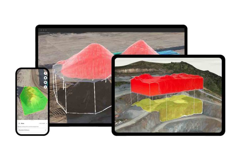
Cut and fill volumes are calculated instantly with visual heat maps showing exactly where material needs to move
Haul road design optimization, reducing equipment costs
Weekly progress tracking against design surfaces
Mass balance analysis prevents expensive dirt import/export
Individual pad elevation verification
Drainage compliance documentation
As-built comparison reporting for each phase
Automated deviation alerts before issues compound
Pre-configured workflows designed for Southeast development requirements
Professional CAD integration, eliminating manual data translation
Quality assurance protocols ensuring engineering acceptance
Regional expertise in understanding regulations in Florida, Alabama, Georgia, Tennessee, South Carolina, and North Carolina
75% faster site evaluation compared to traditional methods
$2,000-$3,000 saved per lot through accurate initial earthwork estimates
10-day average reduction in acquisition decision timeline
Drone measurements achieve accuracy within 1 to 2% of true volume
$250,000+ typical savings on 1M CY projects through optimized haul routing
Weekly verification preventing compound errors and rework
98% first-pass engineering approval rate on as-built packages
60% reduction in lot-level compliance issues
Digital documentation eliminating dispute resolution delays
Our FAA-certified pilots are part of our GeoForge - they are not outsourced subcontractors. This means they can mobilize within 48 hours of your request: no equipment investment, no training requirements, no certification hassles.
Using advanced LiDAR and photogrammetry, we capture your entire site with survey-grade accuracy down to 3cm. Every flight includes ground control verification ensuring engineering-grade precision.
Within 24 hours, our team processes raw data through Propeller's proven platform, then applies professional configuration specific to your development requirements.
Access your intelligence through TerraPilot's™ intuitive interface or download CAD-ready files. Your entire team—from land acquisition to vertical construction—works from the same trusted data.
The GeoForge Advantage:
What's Included:
Complimentary Site Analysis - We'll map up to 50 acres at no charge
Custom Intelligence Report - Receive cut-fill calculations, topographic data, and CAD files
ROI Assessment - Understand exactly how TerraPilot improves your specific projects
Team Demonstration - Include your engineers, PMs, and field teams
No-Obligation Consultation - Discuss your unique requirements with our technical team
Drone pilots capture images. We deliver development intelligence. Our TerraPilot platform transforms aerial data into engineer-ready surfaces, CAD-integrated deliverables, and actionable insights your entire team can use immediately.
We complement and enhance ground-based data collection. While specific regulatory requirements need traditional approaches, our aerial intelligence handles 90% of your recurring data needs faster and more cost-effectively.
Our flexible scheduling and regional pilot network minimize weather impacts. If conditions prevent flying, we reschedule within 48 hours at no additional charge.
With ground control points, accuracy reaches 3cm horizontally and 5cm vertically—sufficient for all development planning and most engineering applications. Unlike our competitors, we do not charge you a project setup fee that includes setting up ground control to ensure our deliverables are accurate. We feel it should not cost our clients thousands of dollars to ensure they get accurate data, so we built the workflows into our highly competitive pricing model.
Absolutely. We regularly collaborate with regional engineering firms and can deliver data in their preferred formats. Many engineers prefer our pre-processed, CAD-ready deliverables. If your existing engineering firm does not have a drone team, we can even become a ready-built drone program for them, integrating with their existing crews for the same cost as traditional methods.
GeoForge delivers an average of 30% cost savings over 12+ month project durations compared to TraceAir. We offer transparent, fixed pricing with no setup fees for establishing ground control points. At the same time, TraceAir charges variable rates based on project size and includes setup costs that can impact your budget. With GeoForge, you know what you will pay each month, and you can change your flight cadence at any time, without penalty.
How do we know? Because the clients who switch to us from TraceAir cite cost as a consistent reason.
GeoForge hires pilots directly as employees and provides them with the right equipment for each specific job, ensuring consistent quality and accountability. TraceAir uses independent contractor pilots who may vary in experience levels and equipment quality, which can affect data consistency across your projects.
GeoForge operates as a solutions provider, delivering expertly configured data collection and processing services rather than requiring you to learn and utilize software platforms to maximize ROI. While TraceAir provides a software interface you need to master, GeoForge handles the technical complexity and delivers engineer-ready results that integrate directly with your existing workflows. Instead of investing millions of dollars into our own software, GeoForge leverages the power of Propeller Aero's leading delivery platform and robust APIs to build custom deliverables tailored to clients' needs. We are a trusted advisor, not a software provider.
No.
GeoForge never charges setup fees to establish ground control points. We include professional ground control establishment as part of our comprehensive service, eliminating the unexpected costs that many competitors add to project budgets.
GeoForge provides complete solutions where we handle data collection, processing, and delivery of engineer-ready results.
DroneDeploy is a software platform that requires you to operate drones, process data, and interpret results yourself. We eliminate the learning curve and technical complexity by delivering professional-grade outputs directly to your team.
No.
GeoForge provides end-to-end service, including our directly-hired pilots and professional-grade equipment.
DroneDeploy requires you to purchase drones, train operators, and manage your own flight operations. We handle all technical aspects so you can focus on your development projects.
GeoForge offers fixed pricing with no setup fees and averages 30% cost savings over 12+ month projects.
DroneDeploy charges subscription fees plus requires significant upfront investment in drones, training, and ongoing software licenses. When you factor in equipment, training, and internal resource costs, GeoForge typically provides better total project economics.
GeoForge includes everything - no setup fees for ground control, no equipment purchases, no training costs.
DroneDeploy's platform fee is just the starting point; you'll need to invest in compatible drones, pilot training, processing hardware, and potentially additional software modules, which can significantly increase total costs.
GeoForge provides professional consultation and technical expertise as core services, with our team handling complex data processing and quality assurance.
DroneDeploy offers software support, but you're responsible for flight operations, data collection quality, and technical problem-solving. Our approach means you get expert results without needing in-house drone expertise.
GeoForge delivers engineer-ready surfaces, cut/fill dashboards, and CAD-compatible data specifically configured for land development workflows.
DroneDeploy provides raw mapping outputs that require additional processing and interpretation to meet professional development standards. We bridge the gap between drone data and actionable project intelligence.